Midwest Map
This Midwest map shows the 12 states the U.S. Census Bureau counts as the Midwest, from Ohio to the Dakotas, Nebraska and Kansas. The region had 68,985,454 people in 2020 (20.8% of the US) on 821,726 sq mi.
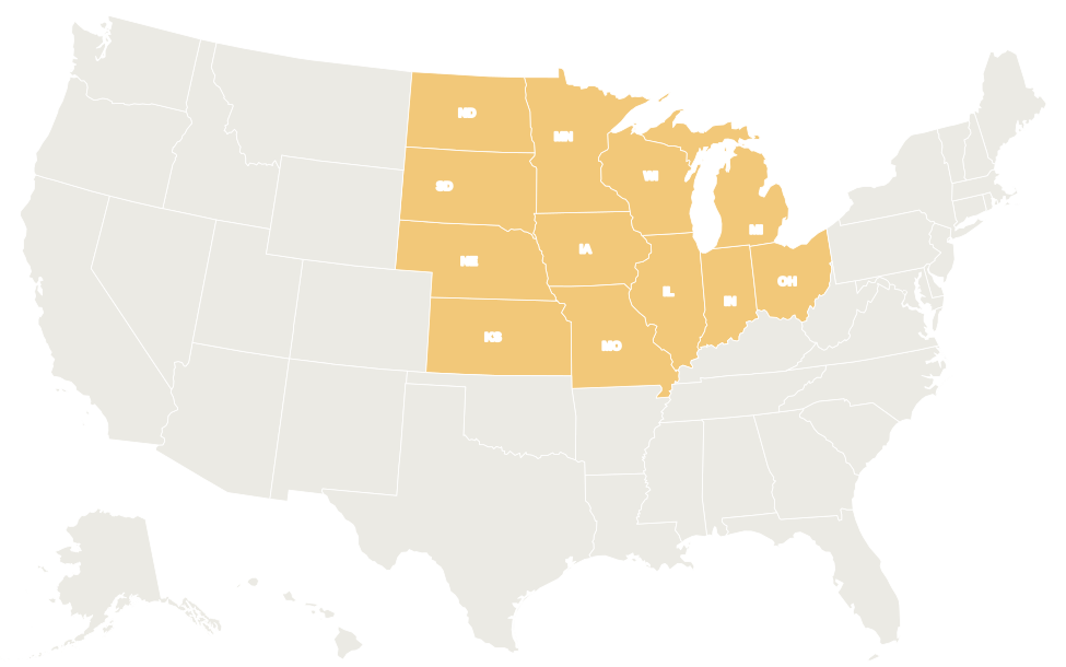
The 12 Midwestern states are shaded yellow. In the interactive map, hover over a state for its name or click it for its capital and population.
States in the Midwest
Select a column heading to sort. Illinois is the most populous Midwestern state and North Dakota the least. Michigan has the largest total area, much of it Great Lakes water.
| State | Capital | Population (2020) | Area (sq mi) | Statehood |
|---|---|---|---|---|
| Illinois | Springfield | 12,812,508 | 57,914 | 1818 |
| Indiana | Indianapolis | 6,785,528 | 36,420 | 1816 |
| Iowa | Des Moines | 3,190,369 | 56,273 | 1846 |
| Kansas | Topeka | 2,937,880 | 82,278 | 1861 |
| Michigan | Lansing | 10,077,331 | 96,714 | 1837 |
| Minnesota | Saint Paul | 5,706,494 | 86,936 | 1858 |
| Missouri | Jefferson City | 6,154,913 | 69,707 | 1821 |
| Nebraska | Lincoln | 1,961,504 | 77,348 | 1867 |
| North Dakota | Bismarck | 779,094 | 70,698 | 1889 |
| Ohio | Columbus | 11,799,448 | 44,826 | 1803 |
| South Dakota | Pierre | 886,667 | 77,116 | 1889 |
| Wisconsin | Madison | 5,893,718 | 65,496 | 1848 |
| Midwest total | 68,985,454 | 821,726 |
East North Central division
Illinois, Indiana, Michigan, Ohio and Wisconsin have 47,368,533 people, more than two thirds of the Midwest’s population, on 301,370 sq mi. All five border at least one Great Lake.
All five were carved from the Northwest Territory created in 1787. Their lakeshore and river cities, such as Chicago, Detroit, Cleveland and Milwaukee, grew as centers of steel, automobile and other manufacturing.
West North Central division
Iowa, Kansas, Minnesota, Missouri, Nebraska, North Dakota and South Dakota cover 520,356 sq mi but have only 21,616,921 people. Most of the division came to the US through the Louisiana Purchase of 1803.
It is farm and ranch country: corn and soybeans in Iowa and Minnesota, wheat in Kansas and the Dakotas, cattle on the Nebraska Sandhills. North Dakota and South Dakota are among the five least populous states.
Geography
- Great Lakes: Midwestern states border Lakes Superior, Michigan, Huron and Erie. Lake Michigan is the only Great Lake entirely within the US. Michigan is split into the Lower Peninsula and the Upper Peninsula, joined by the Mackinac Bridge.
- Rivers: the Mississippi rises at Lake Itasca in Minnesota and forms much of the boundary between Midwestern states. The Missouri River flows from Montana through the Dakotas and along the Nebraska–Iowa line to the Mississippi near St. Louis; the Ohio River forms the southern border of Ohio, Indiana and Illinois.
- Plains and uplands: flat glacial plains in the east give way to the higher, drier Great Plains in the west. The Black Hills of South Dakota rise to Black Elk Peak, about 7,242 ft, the region’s highest point. The Ozark Plateau covers southern Missouri.
- Climate: continental, with hot summers and cold winters; winters are harshest in Minnesota and North Dakota. Severe thunderstorms and tornadoes are common in spring and summer on the Plains.
- National parks: Badlands and Wind Cave (South Dakota), Theodore Roosevelt (North Dakota), Voyageurs (Minnesota), Isle Royale (Michigan), Indiana Dunes (Indiana), Cuyahoga Valley (Ohio) and Gateway Arch (Missouri).
Major cities
The Midwest’s largest cities by 2020 Census population. Kansas City’s metro area straddles the Missouri–Kansas line; the figure below is for the larger city on the Missouri side.
| Rank | City | State | Population (2020) |
|---|---|---|---|
| 1 | Chicago | Illinois | 2,746,388 |
| 2 | Columbus | Ohio | 905,748 |
| 3 | Indianapolis | Indiana | 887,642 |
| 4 | Detroit | Michigan | 639,111 |
| 5 | Milwaukee | Wisconsin | 577,222 |
| 6 | Kansas City | Missouri | 508,090 |
| 7 | Omaha | Nebraska | 486,051 |
| 8 | Minneapolis | Minnesota | 429,954 |
| 9 | Wichita | Kansas | 397,532 |
| 10 | Cleveland | Ohio | 372,624 |
Informal sub-regions
- Great Lakes region: the lake states of the East North Central division, plus Minnesota and the shores of New York and Pennsylvania.
- Upper Midwest: usually Minnesota, Wisconsin, Michigan and Iowa, often with the Dakotas.
- Great Plains: the Dakotas, Nebraska and Kansas, part of a grassland that continues south into Oklahoma and Texas.
- Corn Belt: the corn and soybean country of Iowa, Illinois, Indiana and neighboring states.
- Rust Belt: the older industrial cities around the Great Lakes, from Ohio and Michigan to Illinois and Wisconsin.
- Ozarks: the hilly south of Missouri, shared with Arkansas.
Printable Midwest map
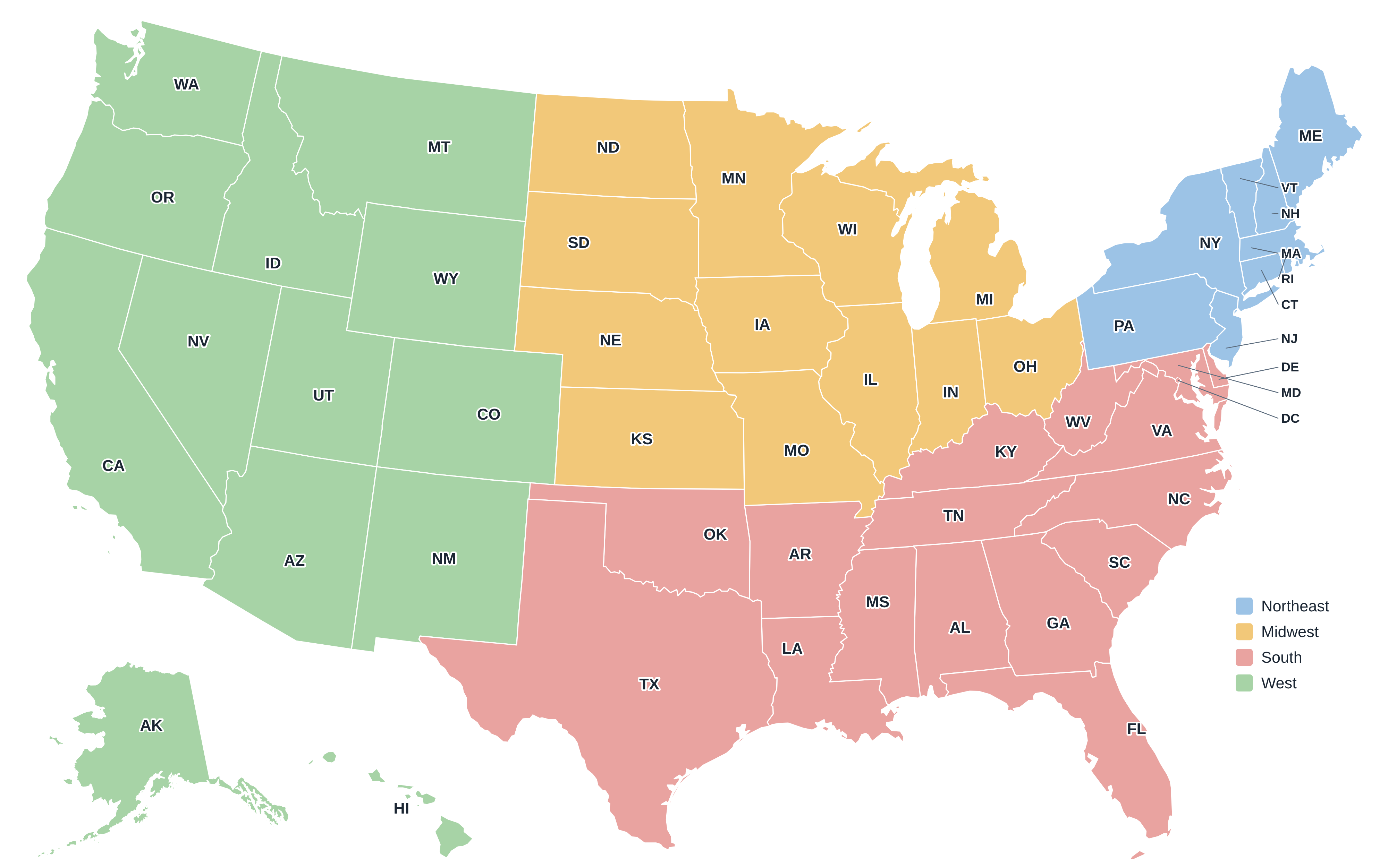
Download the Midwest map above as an SVG, or the full US regions map as a PDF or PNG. More maps are on the printable US maps page.
Frequently asked questions
Which states are in the Midwest?
Illinois, Indiana, Iowa, Kansas, Michigan, Minnesota, Missouri, Nebraska, North Dakota, Ohio, South Dakota and Wisconsin.
Is Kentucky in the Midwest?
No. The Census Bureau places Kentucky in the South (East South Central division), even though it borders three Midwestern states across the Ohio River.
Why is it called the Midwest if it is in the center of the country?
When the US ended at the Mississippi, this area was the western frontier, known as the Northwest Territory. The name “Middle West” stuck after the country expanded to the Pacific.
What is the largest city in the Midwest?
Chicago, with 2,746,388 people in 2020, is the largest city in the Midwest and the third largest in the US.
Other US regions
Northeast · South · West · Compare all four on the US regions map.
Back to the US state map or browse all 50 state maps.
Sources: U.S. Census Bureau (2020 Census, census regions and divisions, boundaries), USGS. Last reviewed October 2026.