Northeast Region Map
This Northeast region map shows the nine states the U.S. Census Bureau groups as the Northeast, from Maine to Pennsylvania. It is the smallest of the four regions by area (181,319 sq mi) but home to 57,609,148 people, 17.4% of the US population in 2020.
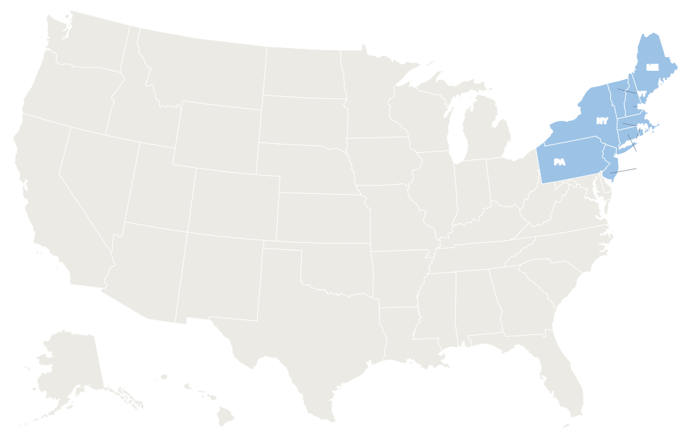
The nine Northeast states are shaded blue. In the interactive map, hover over a state for its name or click it for its capital and population.
States in the Northeast
Select a column heading to sort. New York is the largest state in the region by both population and area; Rhode Island is the smallest state in the country.
| State | Capital | Population (2020) | Area (sq mi) | Statehood |
|---|---|---|---|---|
| Connecticut | Hartford | 3,605,944 | 5,543 | 1788 |
| Maine | Augusta | 1,362,359 | 35,380 | 1820 |
| Massachusetts | Boston | 7,029,917 | 10,554 | 1788 |
| New Hampshire | Concord | 1,377,529 | 9,349 | 1788 |
| New Jersey | Trenton | 9,288,994 | 8,723 | 1787 |
| New York | Albany | 20,201,249 | 54,555 | 1788 |
| Pennsylvania | Harrisburg | 13,002,700 | 46,054 | 1787 |
| Rhode Island | Providence | 1,097,379 | 1,545 | 1790 |
| Vermont | Montpelier | 643,077 | 9,616 | 1791 |
| Northeast total | 57,609,148 | 181,319 |
New England division
Connecticut, Maine, Massachusetts, New Hampshire, Rhode Island and Vermont make up New England. Together they have 15,116,205 people on 71,987 sq mi; Massachusetts alone accounts for almost half the population, and Maine for almost half the area.
All six were settled as English colonies in the 1600s, and town government still matters more here than anywhere else in the country: Connecticut and Rhode Island have no county governments at all. Vermont is the only New England state without an ocean coast.
Middle Atlantic division
New Jersey, New York and Pennsylvania hold 42,492,943 people, nearly three quarters of the Northeast’s population. The Delaware River forms the boundary between Pennsylvania and New Jersey, and the New York City metro area spreads across parts of New York, New Jersey and Connecticut.
New Jersey is the most densely populated state in the US. New York and Pennsylvania reach west to the Great Lakes: both border Lake Erie, and New York also borders Lake Ontario.
Geography
- Mountains: the Appalachian chain runs through the region as the White Mountains (New Hampshire), Green Mountains (Vermont), Berkshires (Massachusetts), Catskills (New York) and the ridges and Allegheny Plateau of Pennsylvania. New York’s Adirondacks form a separate dome. Mount Washington in New Hampshire, about 6,288 ft, is the region’s highest point.
- Rivers: the Connecticut River, New England’s longest, flows south between Vermont and New Hampshire to Long Island Sound. The Hudson runs from the Adirondacks to New York Harbor; the Delaware and Susquehanna drain Pennsylvania toward the Atlantic and Chesapeake Bay.
- Coasts: the rocky shore of Maine, Cape Cod, Long Island and the sandy Jersey Shore. Niagara Falls lies on the border between New York and Ontario, Canada.
- Climate: winters are cold and snowy in northern New England, upstate New York and the mountains; the coast from Boston to Philadelphia is milder. Coastal storms called nor’easters bring heavy snow or rain in winter.
- Protected land: Acadia in Maine is the only national park in the Northeast. New York’s Adirondack Park, a mix of public and private land, is larger than any national park in the lower 48 states.
Major cities
The Northeast’s largest cities by 2020 Census population. Most lie on the Boston–New York–Philadelphia corridor along I-95.
| Rank | City | State | Population (2020) |
|---|---|---|---|
| 1 | New York City | New York | 8,804,190 |
| 2 | Philadelphia | Pennsylvania | 1,603,797 |
| 3 | Boston | Massachusetts | 675,647 |
| 4 | Newark | New Jersey | 311,549 |
| 5 | Pittsburgh | Pennsylvania | 302,971 |
| 6 | Jersey City | New Jersey | 292,449 |
| 7 | Buffalo | New York | 278,349 |
| 8 | Yonkers | New York | 211,569 |
| 9 | Rochester | New York | 211,328 |
| 10 | Worcester | Massachusetts | 206,518 |
Informal sub-regions
- Northern and southern New England: Maine, New Hampshire and Vermont are rural and forested; Connecticut, Massachusetts and Rhode Island are more urban.
- Mid-Atlantic: New York, New Jersey and Pennsylvania, often with Delaware, Maryland and Washington, D.C., which the Census Bureau places in the South.
- Tri-State Area: the New York City metro area in New York, New Jersey and Connecticut.
- Upstate New York: the state north of the New York City area, including Albany, Syracuse, Rochester and Buffalo.
- Appalachia: most of Pennsylvania and New York’s Southern Tier fall within the federal Appalachian Regional Commission area.
Printable Northeast region map
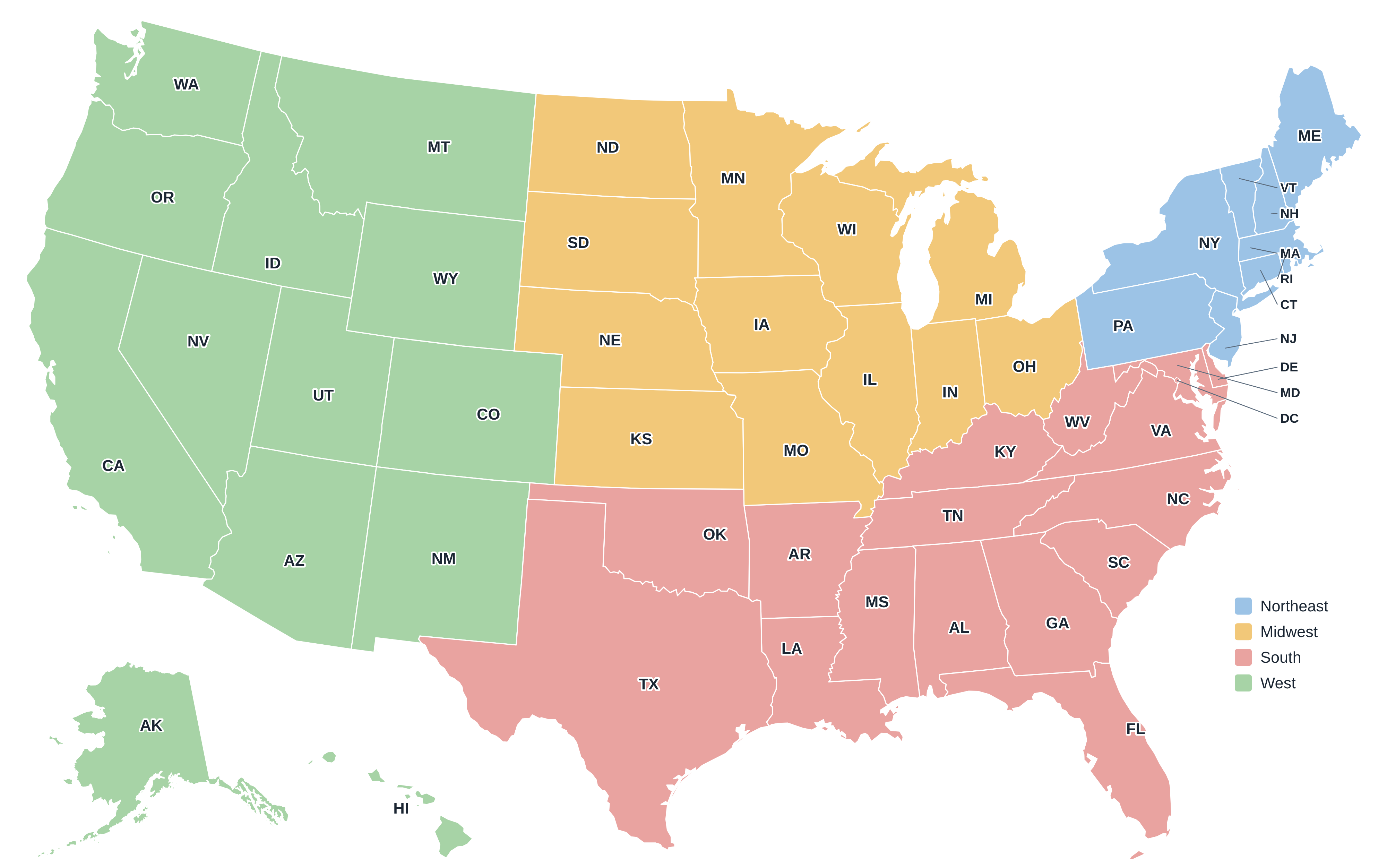
Download the Northeast map above as an SVG, or the full US regions map as a PDF or PNG. More maps are on the printable US maps page.
Frequently asked questions
Which states are in the Northeast?
Connecticut, Maine, Massachusetts, New Hampshire, New Jersey, New York, Pennsylvania, Rhode Island and Vermont.
Is Maryland in the Northeast?
Not in Census terms. The Census Bureau puts Maryland and Delaware in the South Atlantic division, although many people call them Mid-Atlantic states.
What is the difference between New England and the Northeast?
New England is the six-state division in the north and east of the region. The Northeast also includes the Middle Atlantic states of New York, New Jersey and Pennsylvania.
What is the largest state in the Northeast?
New York, with 54,555 sq mi and 20,201,249 people in 2020. Pennsylvania is second by both measures.
Other US regions
Midwest · South · West · Compare all four on the US regions map.
Back to the US state map or browse all 50 state maps.
Sources: U.S. Census Bureau (2020 Census, census regions and divisions, boundaries), USGS. Last reviewed October 2026.