US States by Size (Area)
All 50 US states ranked by size, from Alaska (665,384 sq mi) to Rhode Island (1,545 sq mi). The figures are total area, which counts water (inland lakes and rivers, coastal waters and the Great Lakes) as well as land.
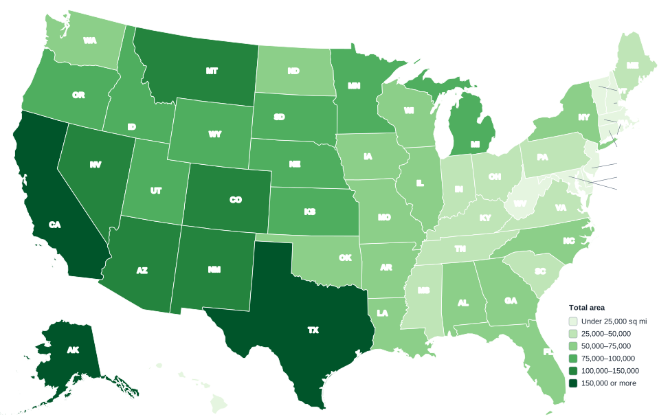
Each state is shaded into one of six classes by total area (land plus water). Alaska and Hawaii are shown at different scales from the other states, so compare sizes using the numbers, not the map.
All 50 states ranked by total area
| Rank | State | Total area (sq mi) | Total area (km²) | Region |
|---|---|---|---|---|
| 1 | Alaska | 665,384 | 1,723,337 | West |
| 2 | Texas | 268,596 | 695,660 | South |
| 3 | California | 163,695 | 423,968 | West |
| 4 | Montana | 147,040 | 380,832 | West |
| 5 | New Mexico | 121,590 | 314,917 | West |
| 6 | Arizona | 113,990 | 295,233 | West |
| 7 | Nevada | 110,572 | 286,380 | West |
| 8 | Colorado | 104,094 | 269,602 | West |
| 9 | Oregon | 98,379 | 254,800 | West |
| 10 | Wyoming | 97,813 | 253,334 | West |
| 11 | Michigan | 96,714 | 250,488 | Midwest |
| 12 | Minnesota | 86,936 | 225,163 | Midwest |
| 13 | Utah | 84,897 | 219,882 | West |
| 14 | Idaho | 83,569 | 216,443 | West |
| 15 | Kansas | 82,278 | 213,099 | Midwest |
| 16 | Nebraska | 77,348 | 200,330 | Midwest |
| 17 | South Dakota | 77,116 | 199,730 | Midwest |
| 18 | Washington | 71,298 | 184,661 | West |
| 19 | North Dakota | 70,698 | 183,107 | Midwest |
| 20 | Oklahoma | 69,899 | 181,038 | South |
| 21 | Missouri | 69,707 | 180,540 | Midwest |
| 22 | Florida | 65,758 | 170,312 | South |
| 23 | Wisconsin | 65,496 | 169,634 | Midwest |
| 24 | Georgia | 59,425 | 153,910 | South |
| 25 | Illinois | 57,914 | 149,997 | Midwest |
| 26 | Iowa | 56,273 | 145,746 | Midwest |
| 27 | New York | 54,555 | 141,297 | Northeast |
| 28 | North Carolina | 53,819 | 139,391 | South |
| 29 | Arkansas | 53,179 | 137,733 | South |
| 30 | Alabama | 52,420 | 135,767 | South |
| 31 | Louisiana | 52,378 | 135,658 | South |
| 32 | Mississippi | 48,432 | 125,438 | South |
| 33 | Pennsylvania | 46,054 | 119,279 | Northeast |
| 34 | Ohio | 44,826 | 116,099 | Midwest |
| 35 | Virginia | 42,775 | 110,787 | South |
| 36 | Tennessee | 42,144 | 109,152 | South |
| 37 | Kentucky | 40,408 | 104,656 | South |
| 38 | Indiana | 36,420 | 94,327 | Midwest |
| 39 | Maine | 35,380 | 91,634 | Northeast |
| 40 | South Carolina | 32,020 | 82,931 | South |
| 41 | West Virginia | 24,230 | 62,755 | South |
| 42 | Maryland | 12,406 | 32,131 | South |
| 43 | Hawaii | 10,932 | 28,314 | West |
| 44 | Massachusetts | 10,554 | 27,335 | Northeast |
| 45 | Vermont | 9,616 | 24,905 | Northeast |
| 46 | New Hampshire | 9,349 | 24,214 | Northeast |
| 47 | New Jersey | 8,723 | 22,592 | Northeast |
| 48 | Connecticut | 5,543 | 14,356 | Northeast |
| 49 | Delaware | 2,489 | 6,446 | South |
| 50 | Rhode Island | 1,545 | 4,002 | Northeast |
Square kilometers are converted from square miles (1 sq mi = 2.589988 km²) and rounded to the nearest whole number.
Largest and smallest states
The five largest states are Alaska, Texas, California, Montana and New Mexico. Nine of the ten largest are in the West; the exception is Texas. Alaska alone covers 17.5% of the area of the 50 states.
The five smallest are Rhode Island, Delaware, Connecticut, New Jersey and New Hampshire, all on the East Coast. Rhode Island, Delaware and Connecticut are each under 6,000 sq mi.
Total area can change a ranking. Michigan ranks 11th with 96,714 sq mi, but more than 40% of that is water, mostly in the Great Lakes.
Size comparisons
- Alaska vs Texas: Alaska is about 2.5 times the size of Texas, and larger than Texas, California and Montana combined (579,331 sq mi).
- Alaska vs Rhode Island: about 431 Rhode Islands would fit inside Alaska.
- Texas: the largest of the 48 contiguous states, at 268,596 sq mi (695,660 km²).
- The Northeast: all nine Northeast states together cover 181,319 sq mi, less than Texas alone.
- The West: its 13 states make up 49.3% of the total area of the 50 states.
Area and population rank very differently: Alaska is 48th in population, and Rhode Island is 43rd. See US states by population.
Frequently asked questions
What is the largest state in the US?
Alaska, with a total area of 665,384 sq mi (1,723,337 km²).
What is the smallest state?
Rhode Island, with 1,545 sq mi (4,002 km²) of total area.
What is the largest state in the contiguous US?
Texas, at 268,596 sq mi. It ranks second only to Alaska.
Do these figures include water?
Yes. Total area is land plus water, including lakes, rivers, coastal waters and each state’s share of the Great Lakes.
Related maps and lists
US states by population
All 50 states ranked by 2020 Census population.
States in order of statehood
The date each state joined the Union, 1787 to 1959.
US regions map
The four Census regions and nine divisions.
US map with capitals
Every state capital marked, with a full list.
State abbreviations
USPS codes and AP style abbreviations for every state.
All 50 state maps
A map, quick facts and printable outline for each state.
Sources: U.S. Census Bureau (state area measurements, boundaries). Last reviewed October 2026.