Southern States Map
This Southern states map shows the 16 states and Washington, D.C., that the U.S. Census Bureau counts as the South, from Delaware to Florida and Texas. It is the most populous region: 126,266,107 people in 2020, 38.1% of the US.
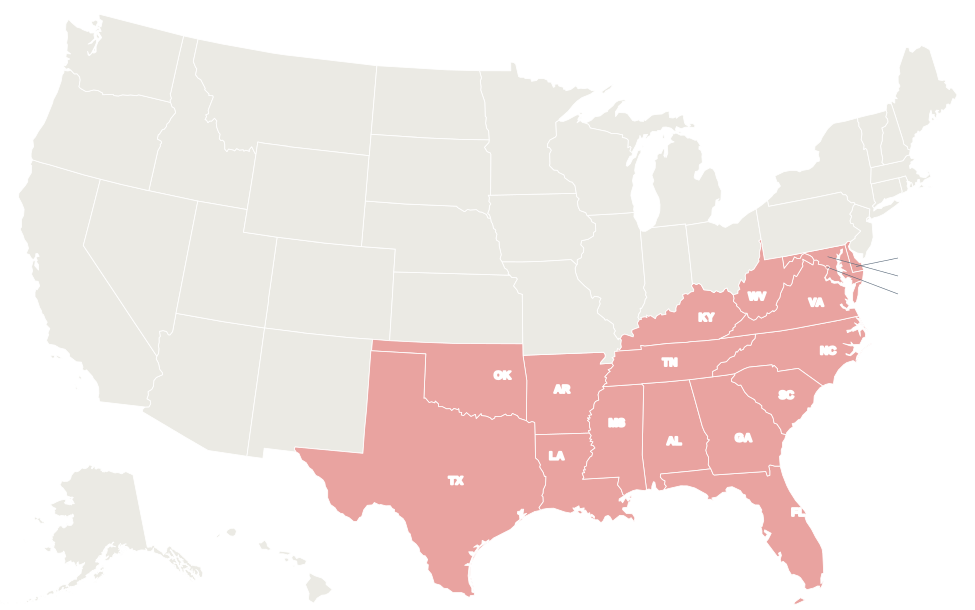
The 16 Southern states are shaded red. In the interactive map, hover over a state for its name or click it for its capital and population.
States in the South
Select a column heading to sort. Texas is the largest Southern state by both population and area; Delaware is the smallest by both. The regional population total includes Washington, D.C.; the area total covers the 16 states.
| State | Capital | Population (2020) | Area (sq mi) | Statehood |
|---|---|---|---|---|
| Alabama | Montgomery | 5,024,279 | 52,420 | 1819 |
| Arkansas | Little Rock | 3,011,524 | 53,179 | 1836 |
| Delaware | Dover | 989,948 | 2,489 | 1787 |
| Florida | Tallahassee | 21,538,187 | 65,758 | 1845 |
| Georgia | Atlanta | 10,711,908 | 59,425 | 1788 |
| Kentucky | Frankfort | 4,505,836 | 40,408 | 1792 |
| Louisiana | Baton Rouge | 4,657,757 | 52,378 | 1812 |
| Maryland | Annapolis | 6,177,224 | 12,406 | 1788 |
| Mississippi | Jackson | 2,961,279 | 48,432 | 1817 |
| North Carolina | Raleigh | 10,439,388 | 53,819 | 1789 |
| Oklahoma | Oklahoma City | 3,959,353 | 69,899 | 1907 |
| South Carolina | Columbia | 5,118,425 | 32,020 | 1788 |
| Tennessee | Nashville | 6,910,840 | 42,144 | 1796 |
| Texas | Austin | 29,145,505 | 268,596 | 1845 |
| Virginia | Richmond | 8,631,393 | 42,775 | 1788 |
| West Virginia | Charleston | 1,793,716 | 24,230 | 1863 |
| Washington, D.C. | (federal district) | 689,545 | 68 | — |
| South total | 126,266,107 | 920,378 |
South Atlantic division
Delaware, Florida, Georgia, Maryland, North Carolina, South Carolina, Virginia and West Virginia, plus Washington, D.C., have 66,089,734 people. Every state except West Virginia has an Atlantic or Chesapeake Bay shoreline.
Delaware, Georgia, Maryland, North Carolina, South Carolina and Virginia were among the original 13 colonies. West Virginia split from Virginia during the Civil War and became a state on June 20, 1863.
East South Central division
Alabama, Kentucky, Mississippi and Tennessee have 19,402,234 people on 183,404 sq mi. They lie between the Appalachians and the Mississippi River, and the Tennessee River loops through Tennessee, Alabama and Kentucky. Mississippi and Alabama reach the Gulf of Mexico; Kentucky and Tennessee are landlocked.
West South Central division
Arkansas, Louisiana, Oklahoma and Texas have 40,774,139 people on 444,052 sq mi. Texas alone, with 29,145,505 people, accounts for about 23% of the South’s population. The Red River marks most of the Texas–Oklahoma border, and oil and natural gas are major industries in Texas, Oklahoma and Louisiana.
Geography
- Mountains: the Appalachians run from West Virginia to northern Alabama. Mount Mitchell in North Carolina, about 6,684 ft, is the highest point east of the Mississippi River. Great Smoky Mountains National Park straddles the Tennessee–North Carolina line. The region’s highest point overall is Guadalupe Peak in West Texas, 8,751 ft.
- Rivers: the Mississippi forms the boundary of Arkansas, Mississippi, Tennessee, Kentucky and Louisiana and reaches the Gulf below New Orleans. The Ohio River marks the northern edge of Kentucky and the western edge of West Virginia; the Rio Grande separates Texas from Mexico.
- Coasts: the Atlantic coast includes Chesapeake Bay, the largest estuary in the US, and North Carolina’s Outer Banks. The Gulf Coast runs from the Florida Keys to Brownsville, Texas. The Everglades cover much of South Florida.
- Climate: mostly humid subtropical, with hot, humid summers and mild winters. South Florida is tropical, and West Texas and western Oklahoma are semi-arid. Atlantic hurricane season runs from June 1 to November 30.
Major cities
The South’s largest cities by 2020 Census population. Five of the ten are in Texas.
| Rank | City | State | Population (2020) |
|---|---|---|---|
| 1 | Houston | Texas | 2,304,580 |
| 2 | San Antonio | Texas | 1,434,625 |
| 3 | Dallas | Texas | 1,304,379 |
| 4 | Austin | Texas | 961,855 |
| 5 | Jacksonville | Florida | 949,611 |
| 6 | Fort Worth | Texas | 918,915 |
| 7 | Charlotte | North Carolina | 874,579 |
| 8 | Washington | District of Columbia | 689,545 |
| 9 | Nashville | Tennessee | 689,447 |
| 10 | Oklahoma City | Oklahoma | 681,054 |
Informal sub-regions
- Deep South: usually Alabama, Georgia, Louisiana, Mississippi and South Carolina, sometimes with northern Florida and East Texas.
- Upper South: Kentucky, Tennessee, Virginia, North Carolina and Arkansas.
- Gulf Coast: the shoreline states of Texas, Louisiana, Mississippi, Alabama and Florida.
- Appalachia: all of West Virginia and the mountain counties of the states from Virginia to Alabama, as defined by the Appalachian Regional Commission.
- Mid-Atlantic: Delaware, Maryland and D.C. are often grouped with the Northeastern states of New Jersey and Pennsylvania.
- Southwest: West Texas and western Oklahoma share their desert and plains landscape with New Mexico.
Printable Southern states map
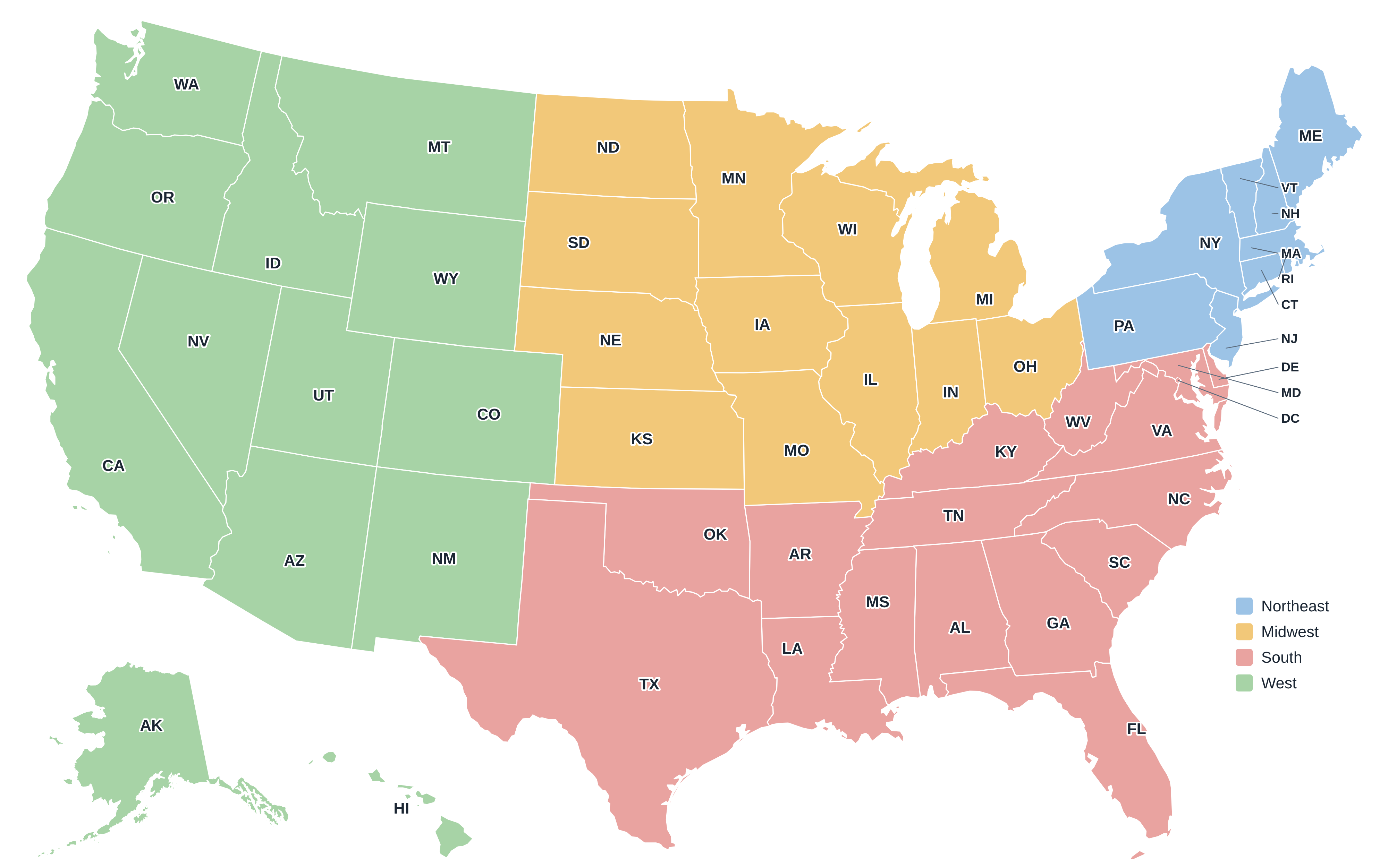
Download the South map above as an SVG, or the full US regions map as a PDF or PNG. More maps are on the printable US maps page.
Frequently asked questions
Which states are considered Southern states?
The Census Bureau counts 16: Alabama, Arkansas, Delaware, Florida, Georgia, Kentucky, Louisiana, Maryland, Mississippi, North Carolina, Oklahoma, South Carolina, Tennessee, Texas, Virginia and West Virginia, plus Washington, D.C.
Is Washington, D.C., in the South?
Yes, for Census purposes. D.C. is in the South Atlantic division, between Maryland and Virginia.
Is Texas in the South or the West?
The Census Bureau places Texas in the South (West South Central division), although West Texas is often described as part of the Southwest.
What is the most populous Southern state?
Texas, with 29,145,505 people in 2020, followed by Florida with 21,538,187.
Other US regions
Northeast · Midwest · West · Compare all four on the US regions map.
Back to the US state map or browse all 50 state maps.
Sources: U.S. Census Bureau (2020 Census, census regions and divisions, boundaries), USGS. Last reviewed October 2026.