New Hampshire State Map
This New Hampshire state map shows a narrow New England state wedged between Maine and Vermont, reaching from the Massachusetts line north to Quebec, Canada, with a short stretch of Atlantic coast. Its capital is Concord and its largest city is Manchester, both on the Merrimack River.
The interactive map shows New Hampshire’s largest cities (capital in red) on an OpenStreetMap base map. Turn on Show counties to see all county lines and hover for names.
New Hampshire quick facts
| Capital | Concord |
|---|---|
| Largest city | Manchester |
| Population (2020) | 1,377,529 (41st of 50) |
| Total area | 9,349 sq mi (46th of 50) |
| Statehood | June 21, 1788 (9th state) |
| Counties | 10 counties · County map |
| Abbreviation | NH (AP style: N.H.) |
| Region | Northeast (New England division) |
| Time zone | Eastern Time (ET) |
| Highest point | Mount Washington, 6,288 ft (Presidential Range) |
| Borders | Quebec, Canada (north); Maine (east); Massachusetts (south); Vermont (west, across the Connecticut River); Atlantic Ocean (southeast) |
Where is New Hampshire?
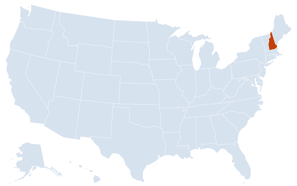
New Hampshire is in the Northeast region of the United States. Neighboring states: Maine, Massachusetts, Vermont.
Largest cities in New Hampshire
| Rank | City | Population (2020) |
|---|---|---|
| 1 | Manchester | 115,644 |
| 2 | Nashua | 91,322 |
| 3 | Concord (capital) | 43,976 |
| 4 | Dover | 32,741 |
| 5 | Rochester | 32,492 |
| 6 | Keene | 23,047 |
| 7 | Portsmouth | 21,956 |
| 8 | Laconia | 16,871 |
Incorporated cities only. Some New Hampshire towns are larger than most cities, led by Derry (34,317), Salem (30,089), Merrimack (26,632) and Londonderry (25,826).
Regions of New Hampshire
New Hampshire is much longer from north to south than it is wide, and it narrows toward the Canadian border. Population is concentrated in the south, within commuting range of Boston; the north is mostly forest and mountains.
- Merrimack Valley: Nashua, Manchester and Concord along the Merrimack River, the state’s urban and political core.
- Seacoast: Portsmouth, Dover, Rochester, Hampton Beach and the Isles of Shoals. New Hampshire has the shortest ocean coastline of any coastal state, and the Piscataqua River forms the border with Maine at Portsmouth.
- Lakes Region: Laconia, Meredith and Wolfeboro around Lake Winnipesaukee, the largest lake in the state, plus Squam Lake and Newfound Lake.
- White Mountains: the Presidential Range, Franconia Notch, Crawford Notch and Pinkham Notch, mostly within the White Mountain National Forest.
- Dartmouth–Lake Sunapee: Hanover (home of Dartmouth College), Lebanon and Claremont along the Connecticut River.
- Monadnock Region: Keene and the southwest corner, dominated by Mount Monadnock.
- Great North Woods: Berlin, Colebrook and the lakes of Pittsburg in Coos County, up to the Canadian border.
Mount Washington and the rivers
Mount Washington, at 6,288 ft the highest peak in the Northeast, is known for severe weather; observers on the summit recorded a wind gust of 231 mph on April 12, 1934. The summit can be reached by the Mount Washington Auto Road or the Cog Railway. The Connecticut River, which begins in the Connecticut Lakes near the Quebec line, forms the entire western border with Vermont; the boundary follows the Vermont bank, so the river itself belongs to New Hampshire. The Merrimack River flows south from Franklin through Concord, Manchester and Nashua into Massachusetts.
New Hampshire counties
The 10 counties and their seats: Belknap (Laconia), Carroll (Ossipee), Cheshire (Keene), Coos (Lancaster), Grafton (North Haverhill), Hillsborough (Manchester and Nashua), Merrimack (Concord), Rockingham (Brentwood), Strafford (Dover) and Sullivan (Newport). Hillsborough and Rockingham, in the south, hold more than half of the state’s people. Below the counties, the state is divided into cities and towns that cover nearly all of its land; a few areas in the north are unincorporated townships, grants and locations.
Major highways
- I-93: the main north–south route, from the Massachusetts line at Salem through Manchester and Concord, then through Franconia Notch to Littleton and Vermont.
- I-89: from Concord northwest to Lebanon and across the Connecticut River toward Burlington, Vermont.
- I-95: a short coastal stretch from Seabrook to Portsmouth, crossing the Piscataqua River into Maine.
- Everett Turnpike (US 3): Nashua to Manchester and Concord.
- NH 101: east–west from Keene through Manchester to Hampton and the coast.
- Spaulding Turnpike and NH 16: Portsmouth to Dover and Rochester, continuing north through Conway and Pinkham Notch to Berlin.
- Kancamagus Highway (NH 112): a scenic route across the White Mountains from Lincoln to Conway.
Printable New Hampshire maps
A blank outline of New Hampshire for coloring, labeling or school projects, and a locator map showing the state within the US. Free for personal and classroom use.
For all 10 counties with county seats and 2020 population, and a printable labeled map, see the New Hampshire county map.
Frequently asked questions
What is the capital of New Hampshire?
Concord, on the Merrimack River about 20 miles north of Manchester. Manchester is the largest city, but not the capital.
How many counties are in New Hampshire?
There are 10 counties. Hillsborough County, which includes Manchester and Nashua, is the most populous; Coos County in the far north is the largest by area.
What time zone is New Hampshire in?
The whole state uses Eastern Time and observes daylight saving time.
Does New Hampshire have a coastline?
Yes, a short one on the Atlantic between Massachusetts and Maine, centered on Hampton, Rye and Portsmouth. It is the shortest ocean coastline of any US state that has one.
Neighboring and nearby states
Maine · Massachusetts · Vermont · Also in the New England division: Connecticut, Maine, Massachusetts, Rhode Island, Vermont
Back to the US state map or browse all 50 state maps.
Sources: U.S. Census Bureau (2020 Census, boundaries), USGS. Last reviewed October 2026.