Kansas County Map
Kansas has 105 counties. Johnson County is the most populous, with 609,863 residents in 2020, and Butler County is the largest by land area at 1,429.7 sq mi. The capital, Topeka, is the seat of Shawnee County.
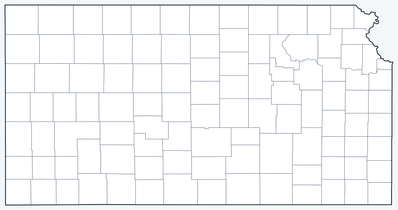
County lines are switched on when the interactive map loads. Hover over a county to see its name, or untick Show counties to hide the lines.
List of Kansas counties
| County | County seat | Population (2020) | Land area (sq mi) |
|---|---|---|---|
| Allen | Iola | 12,526 | 500.3 |
| Anderson | Garnett | 7,836 | 579.6 |
| Atchison | Atchison | 16,348 | 431.2 |
| Barber | Medicine Lodge | 4,228 | 1,134.1 |
| Barton | Great Bend | 25,493 | 895.3 |
| Bourbon | Fort Scott | 14,360 | 635.5 |
| Brown | Hiawatha | 9,508 | 570.9 |
| Butler | El Dorado | 67,380 | 1,429.7 |
| Chase | Cottonwood Falls | 2,572 | 773.1 |
| Chautauqua | Sedan | 3,379 | 638.9 |
| Cherokee | Columbus | 19,362 | 587.6 |
| Cheyenne | St. Francis | 2,616 | 1,019.9 |
| Clark | Ashland | 1,991 | 974.6 |
| Clay | Clay Center | 8,117 | 645.3 |
| Cloud | Concordia | 9,032 | 715.3 |
| Coffey | Burlington | 8,360 | 626.9 |
| Comanche | Coldwater | 1,689 | 788.3 |
| Cowley | Winfield | 34,549 | 1,125.7 |
| Crawford | Girard | 38,972 | 589.8 |
| Decatur | Oberlin | 2,764 | 893.5 |
| Dickinson | Abilene | 18,402 | 847.1 |
| Doniphan | Troy | 7,510 | 393.5 |
| Douglas | Lawrence | 118,785 | 455.8 |
| Edwards | Kinsley | 2,907 | 621.9 |
| Elk | Howard | 2,483 | 644.3 |
| Ellis | Hays | 28,934 | 899.9 |
| Ellsworth | Ellsworth | 6,376 | 715.6 |
| Finney | Garden City | 38,470 | 1,302.0 |
| Ford | Dodge City | 34,287 | 1,098.3 |
| Franklin | Ottawa | 25,996 | 571.8 |
| Geary | Junction City | 36,739 | 384.7 |
| Gove | Gove City | 2,718 | 1,071.7 |
| Graham | Hill City | 2,415 | 898.5 |
| Grant | Ulysses | 7,352 | 574.8 |
| Gray | Cimarron | 5,653 | 868.9 |
| Greeley | Tribune | 1,284 | 778.4 |
| Greenwood | Eureka | 6,016 | 1,143.3 |
| Hamilton | Syracuse | 2,518 | 996.5 |
| Harper | Anthony | 5,485 | 801.3 |
| Harvey | Newton | 34,024 | 539.8 |
| Haskell | Sublette | 3,780 | 577.5 |
| Hodgeman | Jetmore | 1,723 | 860.0 |
| Jackson | Holton | 13,232 | 656.2 |
| Jefferson | Oskaloosa | 18,368 | 532.6 |
| Jewell | Mankato | 2,932 | 910.0 |
| Johnson | Olathe | 609,863 | 473.6 |
| Kearny | Lakin | 3,983 | 870.5 |
| Kingman | Kingman | 7,470 | 863.4 |
| Kiowa | Greensburg | 2,460 | 722.6 |
| Labette | Oswego | 20,184 | 645.4 |
| Lane | Dighton | 1,574 | 717.4 |
| Leavenworth | Leavenworth | 81,881 | 463.4 |
| Lincoln | Lincoln Center | 2,939 | 719.4 |
| Linn | Mound City | 9,591 | 594.1 |
| Logan | Oakley | 2,762 | 1,073.0 |
| Lyon | Emporia | 32,179 | 847.5 |
| Marion | Marion | 11,823 | 944.3 |
| Marshall | Marysville | 10,038 | 900.2 |
| McPherson | McPherson | 30,223 | 898.3 |
| Meade | Meade | 4,055 | 978.1 |
| Miami | Paola | 34,191 | 575.9 |
| Mitchell | Beloit | 5,796 | 701.8 |
| Montgomery | Independence | 31,486 | 643.6 |
| Morris | Council Grove | 5,386 | 695.3 |
| Morton | Elkhart | 2,701 | 729.7 |
| Nemaha | Seneca | 10,273 | 717.4 |
| Neosho | Erie | 15,904 | 571.5 |
| Ness | Ness City | 2,687 | 1,074.7 |
| Norton | Norton | 5,459 | 878.0 |
| Osage | Lyndon | 15,766 | 705.5 |
| Osborne | Osborne | 3,500 | 892.5 |
| Ottawa | Minneapolis | 5,735 | 720.7 |
| Pawnee | Larned | 6,253 | 754.3 |
| Phillips | Phillipsburg | 4,981 | 885.9 |
| Pottawatomie | Westmoreland | 25,348 | 840.7 |
| Pratt | Pratt | 9,157 | 735.0 |
| Rawlins | Atwood | 2,561 | 1,069.4 |
| Reno | Hutchinson | 61,898 | 1,255.3 |
| Republic | Belleville | 4,674 | 717.4 |
| Rice | Lyons | 9,427 | 726.2 |
| Riley | Manhattan | 71,959 | 609.7 |
| Rooks | Stockton | 4,919 | 890.5 |
| Rush | La Crosse | 2,956 | 717.8 |
| Russell | Russell | 6,691 | 886.3 |
| Saline | Salina | 54,303 | 720.2 |
| Scott | Scott City | 5,151 | 717.6 |
| Sedgwick | Wichita | 523,824 | 996.9 |
| Seward | Liberal | 21,964 | 639.7 |
| Shawnee | Topeka | 178,909 | 544.0 |
| Sheridan | Hoxie | 2,447 | 896.0 |
| Sherman | Goodland | 5,927 | 1,056.1 |
| Smith | Smith Center | 3,570 | 895.5 |
| Stafford | St. John | 4,072 | 792.0 |
| Stanton | Johnson City | 2,084 | 680.4 |
| Stevens | Hugoton | 5,250 | 727.3 |
| Sumner | Wellington | 22,382 | 1,181.7 |
| Thomas | Colby | 7,930 | 1,074.7 |
| Trego | WaKeeney | 2,808 | 889.5 |
| Wabaunsee | Alma | 6,877 | 794.3 |
| Wallace | Sharon Springs | 1,512 | 913.7 |
| Washington | Washington | 5,530 | 894.8 |
| Wichita | Leoti | 2,152 | 718.6 |
| Wilson | Fredonia | 8,624 | 570.4 |
| Woodson | Yates Center | 3,115 | 497.8 |
| Wyandotte | Kansas City | 169,245 | 151.6 |
Most populous counties
Kansas had 2,937,880 residents in the 2020 Census. The five most populous counties hold 54.5% of them:
- Johnson County (seat: Olathe): 609,863 people, 20.8% of the state
- Sedgwick County (seat: Wichita): 523,824 people, 17.8% of the state
- Shawnee County (seat: Topeka): 178,909 people, 6.1% of the state
- Wyandotte County (seat: Kansas City): 169,245 people, 5.8% of the state
- Douglas County (seat: Lawrence): 118,785 people, 4.0% of the state
The least populous county is Greeley County, with 1,284 residents.
Largest and smallest counties
By land area, the largest counties are Butler County (1,429.7 sq mi), Finney County (1,302.0 sq mi) and Reno County (1,255.3 sq mi). The smallest are Wyandotte County (151.6 sq mi), Geary County (384.7 sq mi) and Doniphan County (393.5 sq mi).
Butler County is also the largest counting water, at 1,446.5 sq mi in total. The average county covers 778.7 sq mi of land.
How counties work in Kansas
Each Kansas county is governed by an elected board of county commissioners. Wichita, the largest city, is the seat of Sedgwick County, the second most populous county.
Wyandotte County and Kansas City, Kansas, have shared a single Unified Government since 1997. Wyandotte County is also the smallest county by land area (151.6 sq mi). Together with Johnson County, it forms the Kansas side of the Kansas City metro area, which extends into Missouri.
Many western counties are large and thinly settled: Greeley County had only 1,284 residents in 2020, the fewest in the state.
Printable Kansas county maps
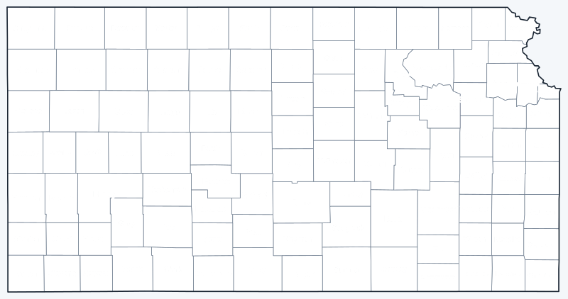
The labeled map shows every county name; the blank version has county lines only, for coloring or quizzes. Both are SVG files that print sharply at any size.
Frequently asked questions
How many counties are in Kansas?
Kansas has 105 counties. Johnson County (seat: Olathe) has the most people, and Greeley County has the fewest.
What is the largest county in Kansas?
Butler County, with 1,429.7 sq mi of land; its seat is El Dorado. Finney County (1,302.0 sq mi) is second.
What is the most populous county in Kansas?
Johnson County, with 609,863 people in 2020, or 20.8% of the state. Sedgwick County is second with 523,824.
What county is Wichita in?
Wichita is in Sedgwick County and is its county seat. Topeka, the capital, is the seat of Shawnee County.
Neighboring state county maps
Colorado county map · Missouri county map · Nebraska county map · Oklahoma county map
Back to the Kansas state map or browse all 50 state maps.
Sources: U.S. Census Bureau (2020 Census, 2020 Gazetteer, boundaries); county seats: Wikidata and Wikipedia county lists. Last reviewed October 2026.